Convict Transportation

A talk by Ian Waller to The East of London Family History Society Newham & Redbridge branch

Ian is a retired professional genealogist with considerable experience in English research. He currently serves as vice chairman and education officer of the Federation of Family History Societies.

Branch meetings take place every month at Wanstead Library
Doors open at 7.00 pm
Refreshments are available
Visitors welcome £3
Parking: Free car parking (car parking charge at Library does not apply to Society branch meetings)


Rural Life in 18th & 19th Century England

A talk by Michael Holland to The East of London Family History Society Newham & Redbridge branch

Michael is a social historian with an interest in agricultural unrest in the 18th & 19th centuries and is currently researching the incidence of acquisitive subsistence crime in East Anglia and links to agricultural unrest. He has worked as an extramural tutor with the University of Essex and also  with the WEA, with around 20 years’ experience in presenting courses and one off talks.

Branch meetings take place every month at Wanstead Library
Doors open at 7.00 pm
Refreshments are available
Visitors welcome £3
Parking: Free car parking (car parking charge at Library does not apply to Society branch meetings)

More on Wanstead crime; burglaries (bad), murders (good)

The real street-level detail of crime in Wanstead in December 2010 is now available from the new Police Crime Maps. The overview for Snaresbrook and Wanstead wards are as follows:
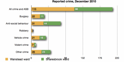
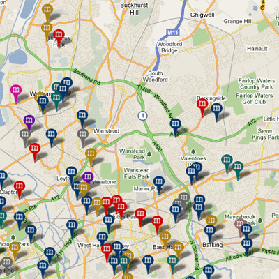
The detailed map shows that burglaries took place on or near Hermitage Walk, Hollybush Hill, Wanstead High Street (2), Wellesley Road, Grove Park (2), Nutter Lane, Leicester Road, Elmcroft Avenue, Elmcroft Close, Limes Avenue, Rodney Road, Colvin Gardens, Blake Hall Road, St Mary’s Avenue, Colebrooke Drive, Redbridge Lane West, Overton Drive, Blake Hall Crescent (2), Park Road, Albury Mews, Dover Road, Clavering Road, Merlin Road and Church Avenue.

When the maps are working fully, it will be easy to compare one neighbourhood with another – and it’s a fair bet that compared to Ilford, Leytonstone and Walthamstow, Wanstead will come out well.  So, ever on the lookout for ways to be of public service, Wansteadium here offers a Nick Ross “don’t have nightmares” thought; the map below comes from Murder Maps, a remarkable site which claims to have plotted all murders in London since the days of Jack the Ripper. Despite all the unfortunate murders indicated on the map, not one of them happened in Wanstead.

Sleep well.

What the new crime maps say about Wanstead

Though the newly-released crime maps for the whole of England struggled with first-day user demand, they will be worth persisting with since they give intriguing portraits of areas which we haven’t seen in this detail before – Wanstead included.

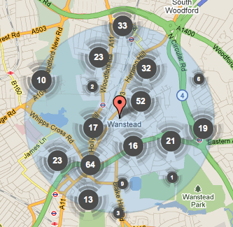
Taking a snapshot of crime within a mile’s radius of a high street postcode – in this case E11 2AA – will necessarily give a flawed picture of Wanstead (which Wansteadium has always taken to mean Snaresbrook and Wanstead wards). For instance, anything south of Green Man roundabout is clearly not Wanstead, as is anything north of Chigwell Road. But, for sake of argument, and taking that as a constant for comparison in future months, we begin to see a picture of criminal activity in our area.

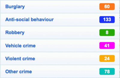
The figures for December 2010 were:

The area as a whole is described in the stats as having an average level of crime, but the numbers of violent crimes and burglaries does seem high for a single month. And the level of anti-social behaviour too will alarm many, though this no doubt includes a lot of low-level annoyance short of criminal behaviour. It might also reflect the ease of reporting activities to visible PCSOs, or even a degree of public-spiritedness among Wanstead residents being prepared to report anti-social goings on.

More details – including street-by-street analysis of offences – will become available as the site gradually copes with demand. Wansteadium for its part will report month by month how crime levels are changing: these maps have been devised as a tool of accountability, though some people have warned that they are likely to lead to increased levels of fear of crime. Others will discuss if it’s better to be aware of crime or oblivious to it, but it’s clear that these new maps could be a boon to the kind of localism people – including the readers of this blog and and hundreds of others around the country – seem to have a growing appetite for.

A Redbridge-led recovery?

The BBC has today published a whole series of statistics about how vulnerable different areas of England are to public sector cuts. They have been calculated by the credit rating agency Experian, which has vast databases of the make-up of the country, and are based on a range of different factors such as the number of people employed in the public sector, life expectancy, benefits etc. The BBC News website has all sorts of whizzy maps to explore on the subject.

The overall picture for Redbridge is that it is almost exactly at the mid-point of vulnerability in England – 166th out of 324 areas. But beneath that are a number of interesting figures.

The borough scores highly for the number of self-employed people – 83rd – and is 50th where earnings are concerned. Crime is relatively high at 231, and considering the image many have of Redbridge it scores poorly – 273rd – for the amount of green space (though given the number of very rural districts in England, this is perhaps not so surprising).

Where Redbridge really stands out is on the number of business start-ups since 2008 – third out of the whole of England, behind neighbouring Barking and Dagenham in second place, and Newham in top spot. This is a fascinating picture of enterprise in east London, perhaps influenced by Olympic investment, and particularly important in difficult economic times when so much store is being set on a revival led by the private sector.