Wanstead the worst in London?

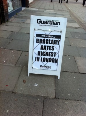
There was at least one cross tweet about the Wanstead Guardian billboard (pictured) last week, and no doubt some degree of eyeball rolling by Wanstead loyalists.

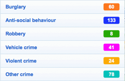
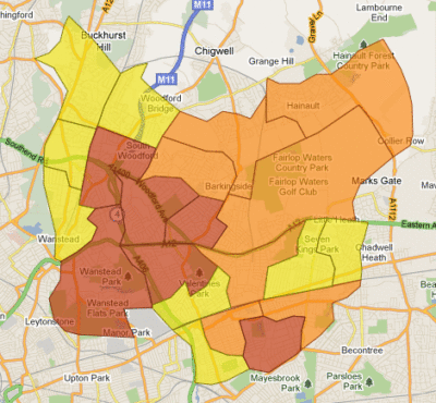
There are probably relatively few people who feel that Wanstead is the worst place in London for burglaries. The new police crime maps do indicate, however, that in January Wanstead ward was one of a number contributing to a high burglary rate in Redbridge – marked in red on the map below. Snaresbrook did not, however, and it’s worth noting that while any burglary is a pain in the neck, the actual numbers are as follows: 28 burglaries in Wanstead ward in January 2011, compared to 20 in December. Snaresbrook had 7 and 11.

It’s always good too to keep an eye on the bigger picture, not just on burglary. Snaresbrook has the lowest overall crime rate of any ward in Redbridge (4.24); Wanstead is higher (8.69) but by no means the worst in Redbridge – there are seven worse. And in the context of neighbouring boroughs, thing become even clearer.

[table id=15 /]

What the new crime maps say about Wanstead

Though the newly-released crime maps for the whole of England struggled with first-day user demand, they will be worth persisting with since they give intriguing portraits of areas which we haven’t seen in this detail before – Wanstead included.

Taking a snapshot of crime within a mile’s radius of a high street postcode – in this case E11 2AA – will necessarily give a flawed picture of Wanstead (which Wansteadium has always taken to mean Snaresbrook and Wanstead wards). For instance, anything south of Green Man roundabout is clearly not Wanstead, as is anything north of Chigwell Road. But, for sake of argument, and taking that as a constant for comparison in future months, we begin to see a picture of criminal activity in our area.

The figures for December 2010 were:

The area as a whole is described in the stats as having an average level of crime, but the numbers of violent crimes and burglaries does seem high for a single month. And the level of anti-social behaviour too will alarm many, though this no doubt includes a lot of low-level annoyance short of criminal behaviour. It might also reflect the ease of reporting activities to visible PCSOs, or even a degree of public-spiritedness among Wanstead residents being prepared to report anti-social goings on.

More details – including street-by-street analysis of offences – will become available as the site gradually copes with demand. Wansteadium for its part will report month by month how crime levels are changing: these maps have been devised as a tool of accountability, though some people have warned that they are likely to lead to increased levels of fear of crime. Others will discuss if it’s better to be aware of crime or oblivious to it, but it’s clear that these new maps could be a boon to the kind of localism people – including the readers of this blog and and hundreds of others around the country – seem to have a growing appetite for.