Wanstead noticeboard: New ticket office opening times

Yes it’s been controversial, the subject of several days’ strike action, but the new hours for ticket office opening on the Underground start today, Sunday 6 February.

For Wanstead station these are the hours:

And for Snaresbrook:

And just for the sake of clarity, here are those numbers again:

[table id=14 /]

Why you can’t rent a Streetcar in Wanstead

Wansteadium reader Michael Proulx got really irritated when he found that Streetcar had withdrawn its vehicles from Wanstead. They had previously had cars parked in Sylvan Road, Woodbine Place and near Wanstead House, and allowed customers to go and pick them up and drive them away. Dedicated parking spaces were allocated to them. Yet he recently found that the cars had been removed, and the nearest site for pick-up was in Leytonstone.

So he wrote to the firm asking why. This is the reply he got:

Dear Michael
Thank you for your email concerning the availability of vehicles in your area.
Unfortunately we have had to withdraw the vehicles from Snaresbrook and Wanstead areas due to a very high volume of attempted break-ins and vandalism with the vehicles. We needed to withdraw these as we could not ensure their safety going forward.
We are currently liaising with the local police to find a way to get around this problem, and we are looking to find secured, off-street parking for vehicles to be placed. This is a lengthy process, so please accept my apologies for the delay whilst we get the issue sorted. We hope to have new vehicles in place soon.

The firm also offered him three months’ rental for free, but since he can’t use it, it doesn’t make a lot of difference.

As Wansteadium reported yesterday, in December 2010 there were 37 instances of vehicle crime (thefts from or of a vehicle, or interference with it) in Wanstead and Snaresbrook, though a detailed breakdown shows much the problem is not as extreme as that: Wanstead’s residential streets had just a handful of reported offences.

More on Wanstead crime; burglaries (bad), murders (good)

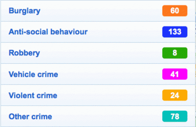
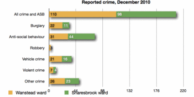
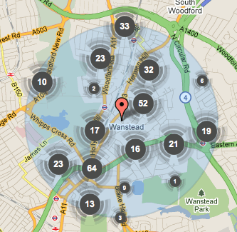
The real street-level detail of crime in Wanstead in December 2010 is now available from the new Police Crime Maps. The overview for Snaresbrook and Wanstead wards are as follows:

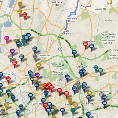
The detailed map shows that burglaries took place on or near Hermitage Walk, Hollybush Hill, Wanstead High Street (2), Wellesley Road, Grove Park (2), Nutter Lane, Leicester Road, Elmcroft Avenue, Elmcroft Close, Limes Avenue, Rodney Road, Colvin Gardens, Blake Hall Road, St Mary’s Avenue, Colebrooke Drive, Redbridge Lane West, Overton Drive, Blake Hall Crescent (2), Park Road, Albury Mews, Dover Road, Clavering Road, Merlin Road and Church Avenue.

When the maps are working fully, it will be easy to compare one neighbourhood with another – and it’s a fair bet that compared to Ilford, Leytonstone and Walthamstow, Wanstead will come out well.  So, ever on the lookout for ways to be of public service, Wansteadium here offers a Nick Ross “don’t have nightmares” thought; the map below comes from Murder Maps, a remarkable site which claims to have plotted all murders in London since the days of Jack the Ripper. Despite all the unfortunate murders indicated on the map, not one of them happened in Wanstead.

Sleep well.

Choice tweets about Wanstead appearing on Relocation Relocation

[blackbirdpie url=”http://twitter.com/#!/yenwodt/status/33253884814172161″]

[blackbirdpie url=”http://twitter.com/#!/HappyFrogandI/status/33259576329502720″]

[blackbirdpie url=”http://twitter.com/#!/nick_affleck/status/33273858911895552″]

[blackbirdpie url=”http://twitter.com/#!/brusma/status/33259817816702976″]

[blackbirdpie url=”http://twitter.com/#!/nick_affleck/statuses/33261661871677440″]

[blackbirdpie url=”http://twitter.com/ellabell84/statuses/33487314042748928″]

You can see the programme again on 4OD. But remember, reality TV can go down as well as up.

”Grand Designs houseboat neglected by couple washes up on beach…. The 33m (100ft) vessel, which had broken free from its mooring along the coast, has earned some belated notoriety after featuring in an edition of the Channel 4 property programme in March 2007. It proved something of a disaster for [an] east London couple [who] wanted somewhere they could go with their children that had more room than their flat in Wanstead, east London.”

(from Metro, Tuesday 1 Feb, 2011)

What the new crime maps say about Wanstead

Though the newly-released crime maps for the whole of England struggled with first-day user demand, they will be worth persisting with since they give intriguing portraits of areas which we haven’t seen in this detail before – Wanstead included.

Taking a snapshot of crime within a mile’s radius of a high street postcode – in this case E11 2AA – will necessarily give a flawed picture of Wanstead (which Wansteadium has always taken to mean Snaresbrook and Wanstead wards). For instance, anything south of Green Man roundabout is clearly not Wanstead, as is anything north of Chigwell Road. But, for sake of argument, and taking that as a constant for comparison in future months, we begin to see a picture of criminal activity in our area.

The figures for December 2010 were:

The area as a whole is described in the stats as having an average level of crime, but the numbers of violent crimes and burglaries does seem high for a single month. And the level of anti-social behaviour too will alarm many, though this no doubt includes a lot of low-level annoyance short of criminal behaviour. It might also reflect the ease of reporting activities to visible PCSOs, or even a degree of public-spiritedness among Wanstead residents being prepared to report anti-social goings on.

More details – including street-by-street analysis of offences – will become available as the site gradually copes with demand. Wansteadium for its part will report month by month how crime levels are changing: these maps have been devised as a tool of accountability, though some people have warned that they are likely to lead to increased levels of fear of crime. Others will discuss if it’s better to be aware of crime or oblivious to it, but it’s clear that these new maps could be a boon to the kind of localism people – including the readers of this blog and and hundreds of others around the country – seem to have a growing appetite for.