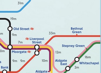
 A map showing walking times between Tube stations to help people during Thursday’s strike has been shared widely on the internet. But unfortunately for the people of Wanstead, the map only comes out of London as far as Bethnal Green.
So as a service to Wansteadium readers, here are walking times to local stations, as calculated by Google Maps.
SNARESBROOK STATION to
- Wood Street – 27 mins (1.3miles)
- Walthamstow Central – 43 mins (2.2miles)
- Leytonstone Tube – 26 mins (1.3miles)
WANSTEAD STATION to
- Manor Park – 41 mins (2.1miles)
- Forest Gate – 36 mins (1.9miles)
- Leytonstone Tube – 20 mins (1mile)
LEYTONSTONE to LEYTON – 24 mins (1.2miles)
LEYTON to STRATFORD – 25 mins (1.3miles)
STRATFORD to MILE END – 42 mins (2.1miles)
MILE END to BETHNAL GREEN – 24 mins (1.2miles)
From there you can pick up the times as detailed on the map, which was produced by Ary Joe Creatives.

